HYDRAULIC PROTECTIONS
Diagnosis of the current state
Quilmes’ present state of susceptibility to flood risk is threefold:
– Due to its low-lying nature, wind-driven ocean surges, termed sudestadas, can penetrate inland the coastline via overland flow and via backflow through natural gravity drainage creeks termed arroyos.
– The arroyos, which provide gravity drainage of precipitation runoff and untreated sewerage to La Plata river, have been anthropogenically altered to constrict their outflows to limited locations. The arroyos are highly channelized, disconnected across sub watersheds, and possess limited to no system storage capacity.
– It is well understood that riverine or surge flood risks may occur independently, but there also exists the possibility of “compound flood risk,” which may occur when both of the conditions noted above occur simultaneously. In this case, sudestada surge inflows may elevate the tailwater condition for the arroyos, which prevents gravity drainage from occurring and causes the arroyos to back up and overtop their banks.
A key geographic feature which plays a hand in both surge inflow behavior and precipitation runoff outflow behavior is the Au Dr. Ricardo Balbin Highway 1. This freeway rests at the historic interface of the estuarine marsh flood plain along the shoreline and the upland transition. Its man-made embankment provides both an unintended, partial protection against sudestada inflows, but also provides an impediment to precipitation runoff outflows since the arroyos must cross under or through the embankment via culverts or other hydrologic control structures. Additionally, the elevated areas within the marsh floodplain that were former garbage dumps provide further barriers to rainfall runoff outflows, yet like the highway, provide some impediment to sudestada inflows. Settlements on the seaward side of the highway in the marsh plain are low lying and susceptible to inundation via sudestadas.
General overview of proposal
Quilmes’ tri-fold exposure to flood risk will require a nuanced series of solutions capable of handling a range of conditions. For most of the time, rainfall runoff flooding is the dominant flood risk driver, whereas sudestada surge inflows or the joint coincidence of rainfall events during sudestadas are likely to be ephemeral in nature, lasting only on the order of hours to days. To defend against the spectrum of events, there are a few primary system components required:
– Rainfall runoff storage- to ensure that both rainfall and joint coincidence events may be handles by the system, internal storage capacity for runoff is required to be present inside the sudestada surge protection line of defense. Maximizing system storage is a widely accepted best practice for stormwater management. Retention and detention lagoons and facilities also allow for the alteration of the runoff hydrograph such that runoff volumes exceeding channel capacities may be temporarily stored and then released at a controlled rate. To accomplish this goal, a system of detention lagoons, enlarged channels, and outflow control structures are proposed. Renaturalization of existing channels and proposed channels will provide value beyond flood risk reduction. Wetland plant species can assist in nutrient removal from outflows, stabilize channel banks, and provide a higher aesthetic appeal to the community.
– Sudestada storm surge protection- a “leaking levee” system is required to allow precipitation drainage for the majority of the time, but which retains an ability to manage one-way outflow. To accomplish this task, flow regulation gates such as flap gates and sluices are proposed to allow rainfall runoff egress without allowing sudestada ingress. To accomplish this goal, it is proposed that the existing highway embankment be utilized for the dual purpose of flood protection. Locating the main line of flood protection along the highway will also make the best use of natural-based defense provided by the estuarine marshes located along the shoreline.
Riverine city considerations
There are many worldwide case studies for coastal city redevelopment plans. Most of these plans bring innovations in engineering, planning, and design to other coastal regions where robust water infrastructure is critical to survival and economic prosperity. It is recommended that for Quilmes, smart building practices such as requirements to construct either the building pad or first floor elevation of all buildings to be above 100- to 500-year (1% to 0.2% annual exceedance probability exceedance) water surface elevation, be instituted. Also, smart building practices should be followed such the at first floors may be floodproofed as future flood risk profiles change. Finally, the location and orientation of the proposed building pads should be oriented such that they do not constrict or limit the egress of storm water runoff from the arroyos.
PREVIOUS STUDIES: BID. RAIN DRAINAGE MASTER PLAN
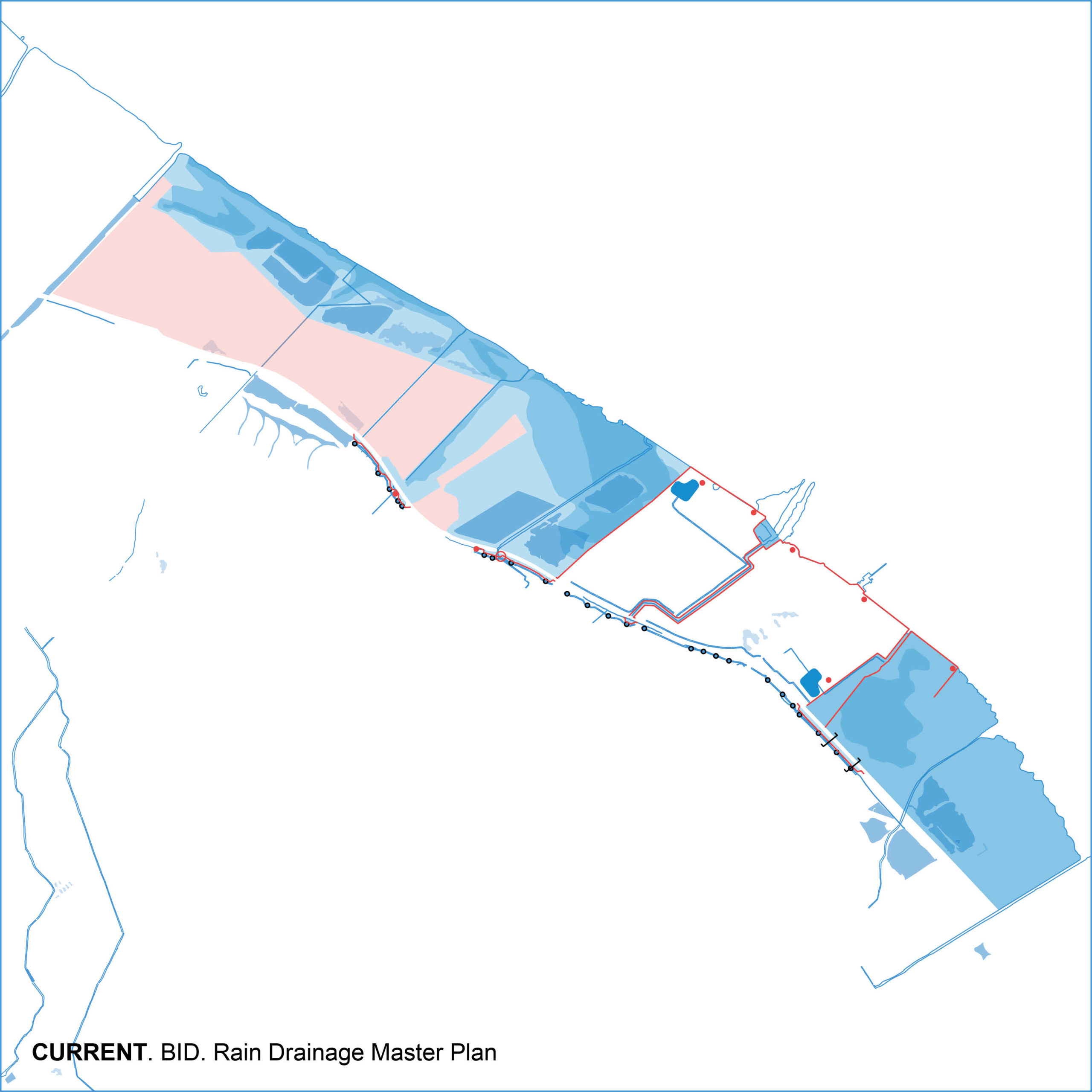
In July 2016, Proyfe SL with the support of the BID (Banco Interamericano de Desarrollo) developed a Rain Drainage Master Plan (PMDP) for the city of Quilmes. The main aspects of the proposal are the following:
In the event of sudestada, the consolidated neighborhoods of the riverside are protected. South of the highway, a new levee is built in the areas where the streams and channels can be a threat.
The levee allows the construction of a distribution channel in parallel to the highway. In the event of sudestada and heavy rainfall at the same time, rainwater to the south of the highway is distributed through this interceptor and pumped to the other side of the highway.
The drainage works under the highway are too big to install a non-return valve, so they are cleaned and widened allowing flood water through them to block it later with an easier system of one way flow flap gates under the new levee.
The east area in the riverside is still to be defined by future developments, the protections are built for future extensions.
PHASING
The plan for the hydraulic protections is designed in two phases, reconsidering and improving the Rain Drainage Master Plan developed by Proyfe SL with the support of the BID.
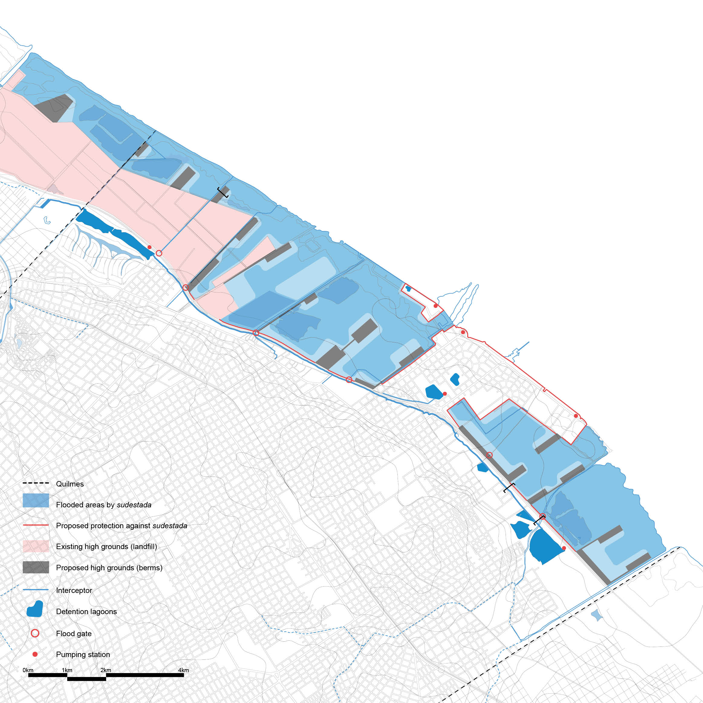
In a first phase, the highway is improved in order to serve as a protection for sudestada itself, adding some flood gates when needed, eliminating the need of a parallel levee. The consolidated neighborhoods in the riverside are also protected with a new system of levees and green protections. The streams in the riverside are widened and converted into green ways.
A channel running parallel to the highway collects rainwater and serves as an increased system storage and for flow equalization across the outlet streams running to La Plata River. This interceptor is accompanied by floodable green spaces that increase its capacity.
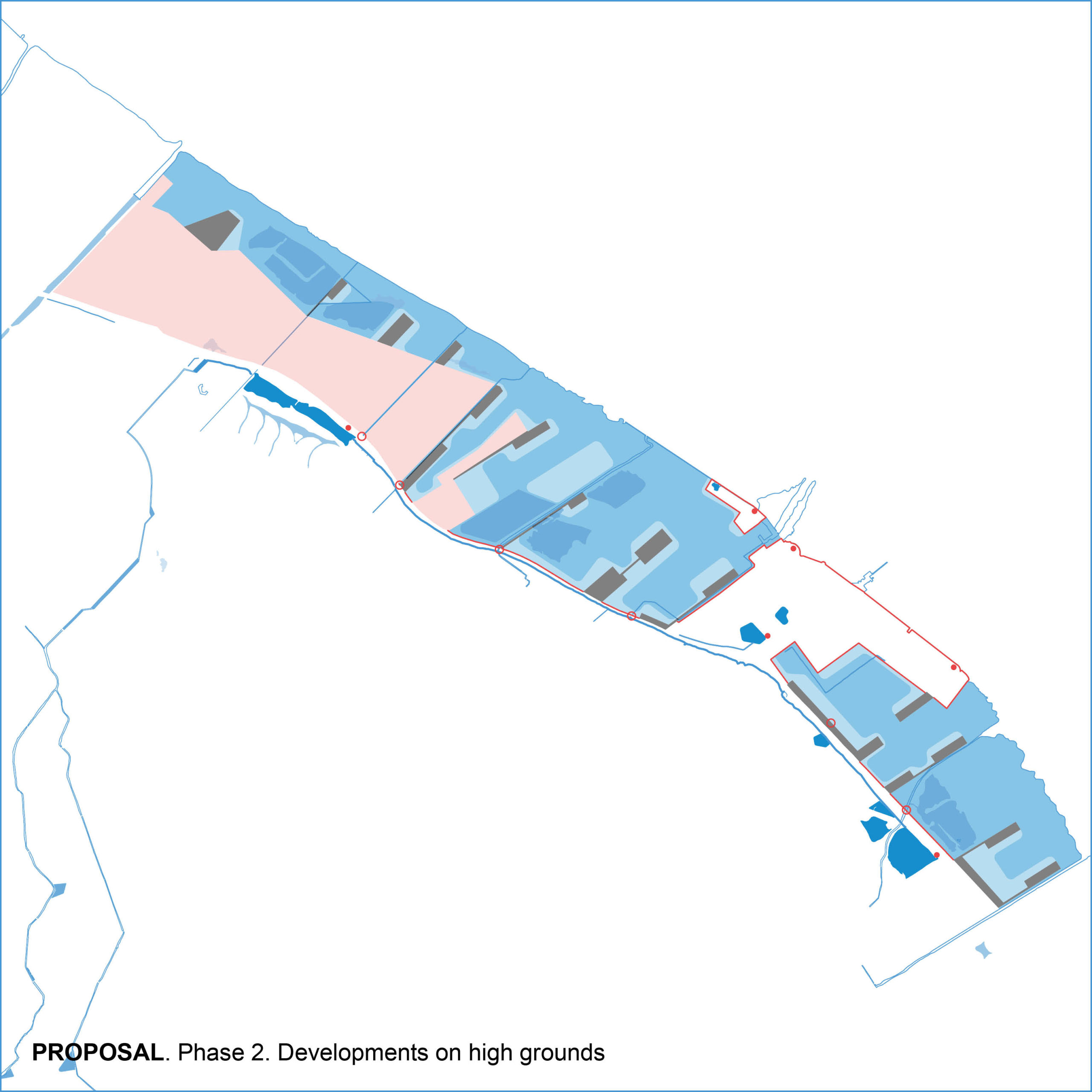
In a second phase, as private developments take place, a system of berms colonize the floodplain in a gentle and respectful way to the riverine ecosystem. Following a ‘pier’ logic.
Ground level is raised to protect new developments from sudestada and shape the flooded area, without need for pumps or new flow flap gates.
FLOOD MANAGEMENT COMPARISON
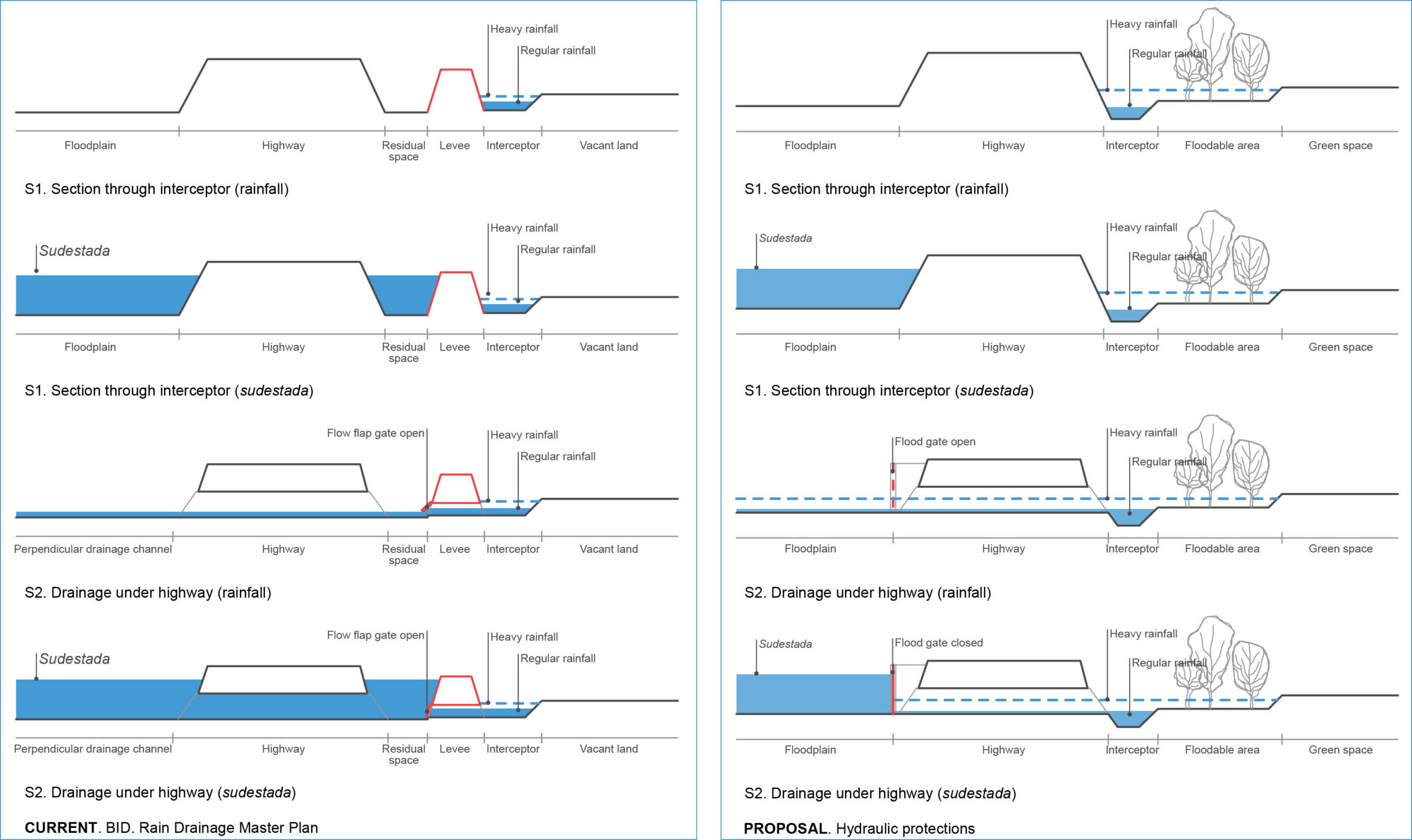
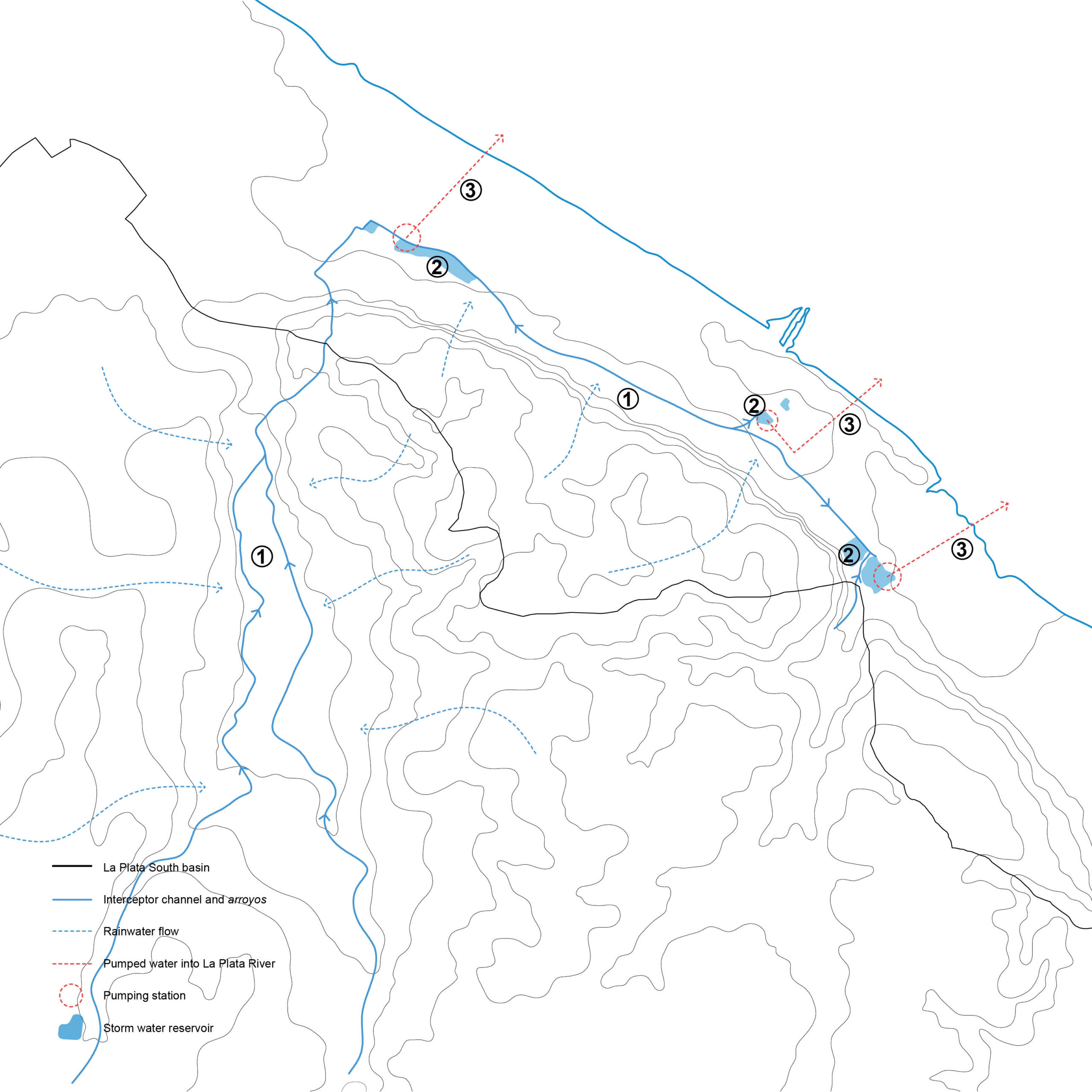
WATER FLOW DURING SUDESTADA
When heavy rain events occur during an external flood (sudestada), water flow follows a clear and simple scheme:
1. Water is intercepted by the arroyos and the new channel parallel to the highway.
2. These interceptors carry water to three main storm water reservoirs.
3. When the reservoirs are at full capacity, water is pumped into La Plata River.
