WATERS
All the hydrological and hydraulic aspects of the strategic vision for Quilmes are considered under the category of Waters. This is, as explained before, the conducting system through which the entire city is understood.
The hydrological system of Quilmes is a complex system of streams and rivers running through the entire city. The main hydrological characteristic of the city is its location on the bed of La Plata River. This means there is a need of a deep understanding of its riparian character. The morphology of the floodplain, the flood logics and the ecosystem of the place has to be reconsidered as it has been ignored or even harmed. It is the case of the floodplain, where artificial lagoons have been excavated and the marshy character of the place has been damaged by urbanizing the area and polluting the ground.
At the same time, a characteristic of the hydrological system of major importance is the presence of two streams that cross the city from south to north. These arroyos are dangerously polluted and are the cause of continuous floods in the area. The streams have been ignored and their original traces have been modified or even covered, considering the streams as a problem rather than as an opportunity for public space and provoking worsened flood scenarios. Also, the relation between water and citizenship is currently non-existing. The streams have been used as a sewer.
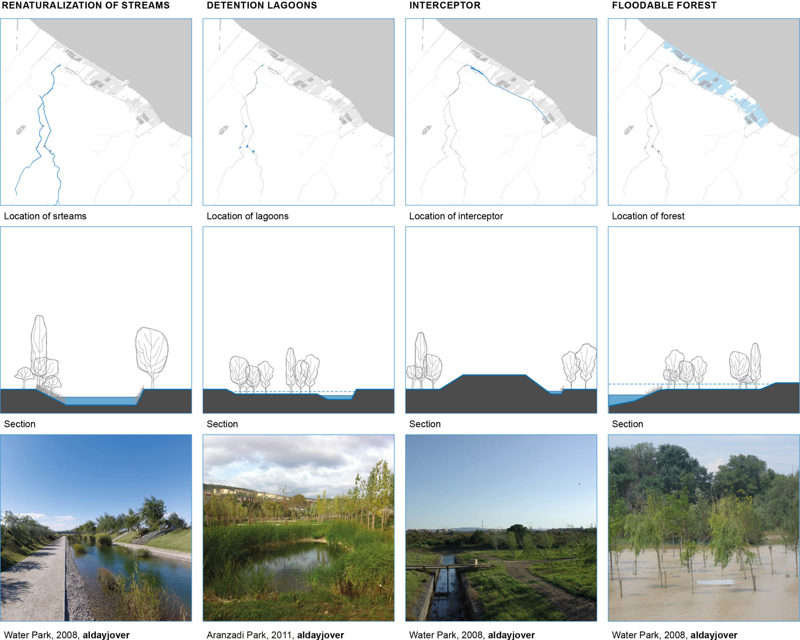
In order to fix this situation, the arroyos are given a new role in the city. They are now considered as vertebral axis for green corridors that connect the entire city. The Acceso Sudeste, a vacant ground where a highway was left unfinished leaving an enormous trace of unused land, is a great opportunity for continuing the arroyos open to daylight. This new river would flow through the Acceso Sudeste and Avenida Las Flores, in Avellaneda, all the way down to the floodplain and connect with the existing drainage channels. The streams are now a fundamental part of public space. In order to stop and slow down high levels of water during heavy rainfall, shared floodable spaces are always considered, in current marshy areas, along the arroyos.
Regarding the floodplain, sudestada is considered as an opportunity for the new definition of the riverside rather than a threat. Through the development of the riverside area new limits for the flood are defined and the highest possible amount of space is shared with water.
Through these interventions a new rain drainage system is developed in order to attend frequent events such as simultaneous sudestada and rainfall events. In the case of both events at the same time, rain water would naturally be intercepted by the arroyos and the new stream running parallel to the highway. After that, water would flow into three main water reservoirs. Finally, once the storage lagoons are at full capacity, water would be pumped into La Plata River.

HYDROLOGICAL STRATEGIES
1. Renaturization of streams: helps integrate water in the public space.
2. Detention lagoons: are shared spaces that help slow water and provide flooding control.
3. Interceptor: parallel to the highway is used for collecting rainwater and manage its drainage.
4. Floodable forest: rethinking floodplain with a new system of hydraulic protections as a usable shared space.

